- blog/
QGIS Plugin: MapSwipe Tool
Table of Contents
I’ve been using ArcGIS for the first time in the last couple of weeks and I’ve come across the Swipe tool. My immediate thought was “oh that’s awesome” which was swiftly followed by “I wonder if QGIS has this as well?”
The answer is yes!
Courtesy of the MapSwipe Tool plugin:
- https://gis.stackexchange.com/questions/172339/swipe-tool-in-qgis
- https://plugins.qgis.org/plugins/mapswipetool_plugin/
- https://github.com/lmotta/mapswipetool_plugin
I encountered a couple of hiccups while trying it out that I thought were worth noting.
QLine python error #
The first one is that the plugin won’t work / will produce a lot of errors that force you to kill QGIS. This will happen if you are using a more up-to-date version of QGIS where the python version behind it is 3.10 or greater. The stacktrace for the errors will look something like this:
WARNING    Traceback (most recent call last):
              File "/home/username/.local/share/QGIS/QGIS3/profiles/default/python/plugins/mapswipetool_plugin/swipemap.py", line 70, in paint
              line = QLine( 0,h-1,w-1,h-1 )
             TypeError: arguments did not match any overloaded call:
              QLine(): too many arguments
              QLine(QPoint, QPoint): argument 1 has unexpected type 'int'
              QLine(int, int, int, int): argument 2 has unexpected type 'float'
              QLine(QLine): argument 1 has unexpected type 'int'
These can be addressed by applying the fix described here:
In short, you need to wrap a couple of calculations with an int() call.
With an older version of QGIS, that is backed by python 3.9, this does not happen. If you happen to look at the log messages console however, you’ll notice a warning that explains why:
DeprecationWarning: an integer is required (got type float). Implicit conversion to integers using __int__ is deprecated, and may be removed in a future version of Python.
Python was automagically making things work by not caring that a float was provided when an int was required.
the Active Layer is the wrong size and in the wrong place #
The next hiccup I encountered was that the MapSwipe Tool Active Layer (whichever layer you have selected when you enable the tool) wasn’t scaled properly. The problem looks exactly like these reports:
- https://gis.stackexchange.com/questions/324519/using-qgis-map-swipe-tool
- MapSwipe Tool does not properly align both images
Unfortunately I don’t have a fix for this one, and so far have only been able to confirm that it appears to relate to OS-level resolution scaling (at least for me, on Fedora / Wayland). When I set my display scale to 100% instead of 200% the MapSwipe Tool worked perfectly (as it does on my Windows desktop, just like the first report linked above).
UPDATE: 20230318
I figured out how to fix this issue!
In my case it seems to relate to the Device Pixel Ratio not being correct. After the following lines in swipemap.py in the setMap function…
settings = QgsMapSettings( self.canvas.mapSettings() )
settings.setLayers( self.layers )
settings.setBackgroundColor( QColor( Qt.transparent ) )
…add this line:
settings.setDevicePixelRatio( 1 )
The PyQGIS docs for QgsMapSettings say that 1 and 2 are common values for the devicePixelRatio:
devicePixelRatio– Returns device pixel ratio Common values are 1 for normal-dpi displays and 2 for high-dpi “retina” displays.
Based on that I thought setting it to 2 might fix it, but it didn’t. I then found that my Device Pixel Ratio was 1 with the help of alacritty -v (via ArchWiki, there are probably other ways to find this out but I happened to have alacritty already installed so it was convenient for me). So I set the value to 1 and tadaaa the MapSwipe Active Layer is now correctly aligned with the layer below it, wahey!
swiping maps on the web #
On the topic of swiping maps, I have a couple of links to share.
If ever I feel the desire to include a swipey map in a blog post, I’ll probably try and do that with this:
And if you want to swipe some maps right now, I recommend visiting this link:
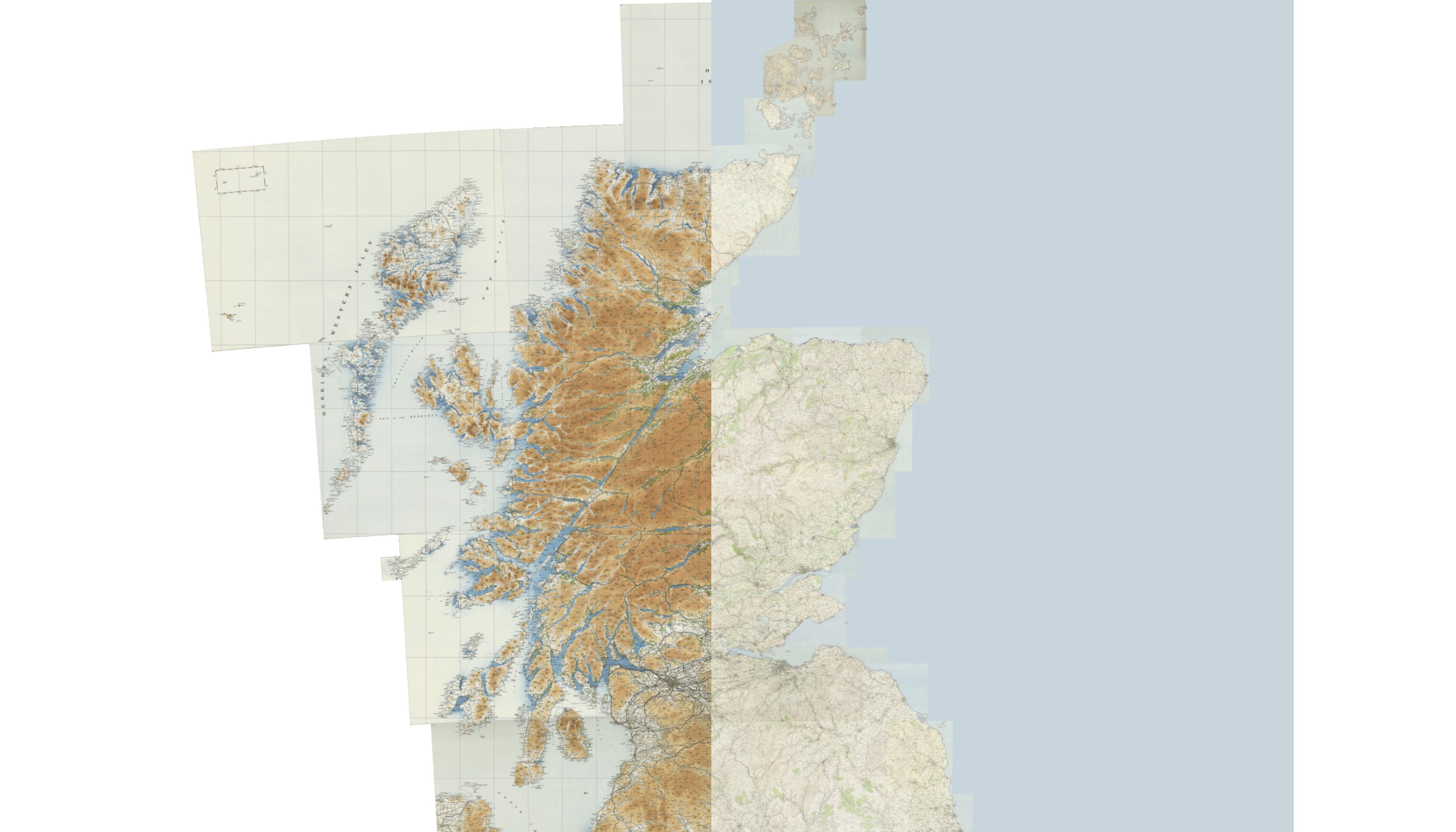
On the left: Scotland series, OS Quarter Inch, Civil Air, 1929-1930.
On the right: Great Britain series, OS One Inch 7th series, 1955-61.